
The Marshalling Science group’s research delves deeply into the role of biota, climate and lithology (or more specifically rock properties) in determining the rates and styles of geomorphic processes through time.
My (and my research group’s) research strongly aligns with understanding past- and present-day influences on the Critical Zone, the life-sustaining, constantly evolving, surface and near-surface earth region extending from the top of the vegetative canopy to the subsurface limit of groundwater.
Thus I am both a geomorphologist and a Critical Zone scientist.
Climate and Landscape Evolution: Climate regulation of erosion in unglaciated landscapes remains difficult to decipher. Easily observable modern ecosystem processes such as tree throw and precipitation-driven erosion can erase the past and bias our interpretation of landscape evolution. Recently I worked with a highly interdisciplinary team to quantify the intensity across the never glaciated Oregon Coast Range, of frost-driven sediment production and erosion during the last glacial maximum by combining downscaled paleoclimate simulations, a new frost weathering model, paleoecology and 10Be-derived data. My results suggest that relative to modern rates, frost weathering promoted increased erosion rates across extensive unglaciated terrain during the last glacial interval. Marshall et al., Science Advances 2015
By coupling high-fidelity cosmogenic radionuclide-derived erosion rate and environmental data from a new 63m paleolake core spanning three climate intervals in the unglaciated Oregon Coast Range, I show that erosion rates track climate-driven changes in tree- vs. frost-controlled weathering and erosion processes. My results suggest that erosion rates were 3-4x greater during the last glacial interval, compared to erosion rates during the forested, inter-glacial intervals. These results are among the first to document potential mechanistic links between climate change and erosion rate variability in unglaciated terrain and challenge the notion that the Oregon Coast Range is an ideal steady-state landscape over millennial timescales. Marshall et al., GSA Bulletin, 2017
Biota and landscape evolution: One can visualize the conversion of bedrock to soil upon observing fresh rock blocks in the roots of a wind-downed tree or when passing a road cut where a layer of mobile soil material overlays weathered rock which overlays the deeper, unaltered bedrock. Yet there is no mechanistic mathematical expression describing the physical conversion of bedrock into mobile material. This critical uncertainty has hampered progress on a broad array of problems. For example, soil thickness, carbon storage in soils, and regulation of atmospheric CO2 by silicate weathering depend on the variety of mechanical processes that can damage bedrock and create mobile grains in sizes small to large. I am taking advantage of the collaborative science, instrumentation, and data at two NSF Critical Zone Observatories (CZOs) to parameterize a soil production function based on measured tree pressures at the root-rock interface and both physical and numerical modeling of tree-driven bedrock damage and detachment. By coupling the novel use of tiny force sensors with accelerometers and anemometers, I can quantify the frequency and magnitude of everything from root growth forces to wind-and snow-driven tree sway events. By working at multiple CZOs with diverse wind patterns, water availability regimes, and forest and rock attributes, I aim to develop a broadly applicable geomorphic law. This work is highly-interdisciplinary and involves hydrologists, geophysicists, ecologists and plant physiologists and frankly its a whole bunch of fun!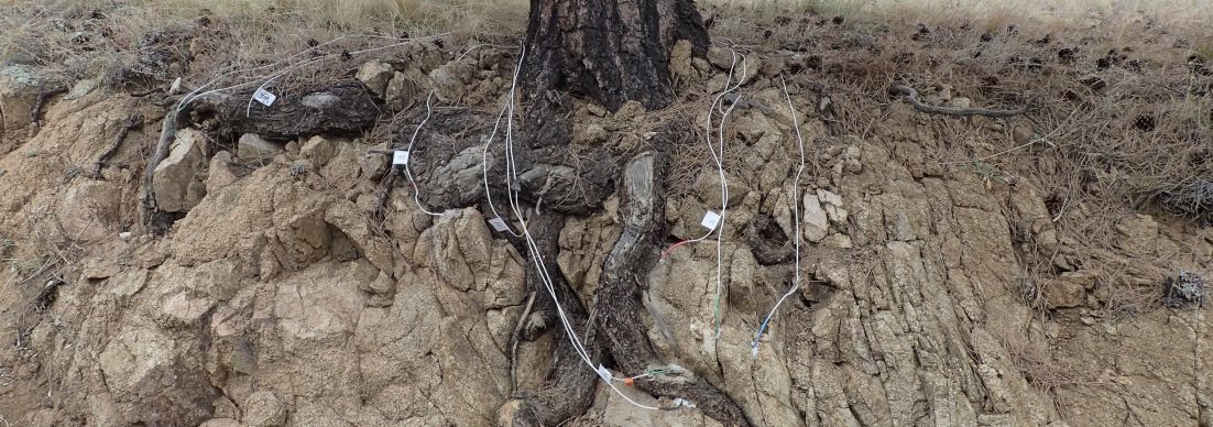
Rock properties and landscape evolution: Following in the footsteps of G.K Gilbert and E. Yatsu, I continually come back to the role of rock properties in controlling the rate and style of bedrock weathering, soil production and erosion. For example, over what scale do minor differences in rock properties in a presumably uniform lithology influence the functional relationship between geomorphic processes and landscape form?’ By using a combination of field work, petrology, rock mechanics and lidar analysis, I demonstrated how extremely minor diagenetic alterations control soil production, relief and landscape evolution in the Oregon Coast Range. At multiple scales my analyses suggest that even small differences in rock properties, occupying as little as ~ 10 % of a watershed can control geomorphic function to such a degree that morphologic deviations attributed to climate or tectonics may actually derive from variability within these ‘uniform’ lithologies. Marshall and Roering, 2014
